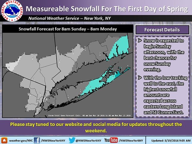
Update - March 19, 2016 - The NWS has updated their forecast for Sunday’s snowstorm, lowering expected snowfall totals to 2” for much of LI and 3” for eastern part of the Island. The potential for snow remains between Sunday afternoon and early Monday morning.
Below is the original story.
March 18, 2016 - Sunday may mark the start of spring, but evidently Mother Nature isn't quite ready for winter to be over. Despite unseasonably warm temperatures over the past couple weeks, Long Island is going to see a cold front move in over the weekend and it will carry a strong possibility of snow with it.
As of Friday evening, the National Weather Service is predicting a high of 33-35° for Sunday with a probability of precipitation. Current forecasts indicate that it will likely start snowing after noon, and that the storm could keep going as late as 8 AM Monday morning.
NWS NY's latest forecast indicates that 4-6" of snowfall is possible across the entire Island with accumulation likely. Fortunately, temperatures are expected to rise into the 40s on Monday, which means much of whatever does fall will quickly melt away.
There is still plenty of time for the storm to shift, which means that expected totals could change between now and Sunday, so keep an eye on the forecast.
For the most up to date weather information, head over to the LongIsland.com Weather Center, where you can find the latest weather forecasts, advisories and more.
To get the latest traffic & road conditions before traveling, visit the LongIsland.com Traffic Center, and be sure to check out the live traffic feeds on our Traffic Cam Page.
Please visit our Long Island School Closures Page for regular updates of school closings in your district.
[Source: NWS]


