April 1st is celebrate by pranksters around the country looking for an excuse to play practical jokes on friends, family, and acquaintances. Long Islanders looking at the weekend forecast couldn't be blamed for thinking that Mother Nature has decided to get in on the fun too.
Despite the fact that spring has just begun, a dip in temperatures combined with cloudy, rainy weather could bring another bout of snow to the area overnight on Saturday. With predicted temperatures in the low-mid 30s and a 60% chance of precipitation heading into Sunday it would not be a surprise to see a little accumulation, mainly after 2 AM Sunday morning.
Fortunately, the National Weather Service is predicting less than an inch of accumulation, and highs over 40° on Sunday will see any snow that does fall melt away quickly, making this taste of winter even less significant than the March 31st snowstorm of 2014. There is a slight chance of snow in the early hours of Monday morning as well, though it is too early to accurately predict how much will fall then.

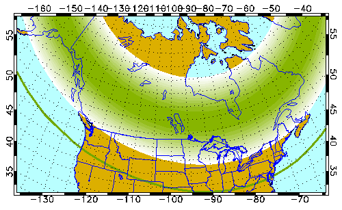
Areas above the green line should be able to see the aurora on 4/2/16. Map provided by UAF.
An even more unusual event is also predicted for Saturday night, as Long Island is in the right place for a rare glimpse of the Northern Lights. Auroral activity will make a rare dip down to our latitudinal level, allowing for the possibility of a highly active auroral display Saturday night. Unfortunately, the lights would be most visible form 10 PM Saturday to 2 AM Sunday morning, when there is a chance of rain showers and a likelihood of cloud coverage.
Still, stargazers who don't mind staying up late would be remiss not to look up to the sky at the very least. If Long Island gets a reprieve from the clouds and precipitation then the aurora would be visible in areas without too much light pollution.


