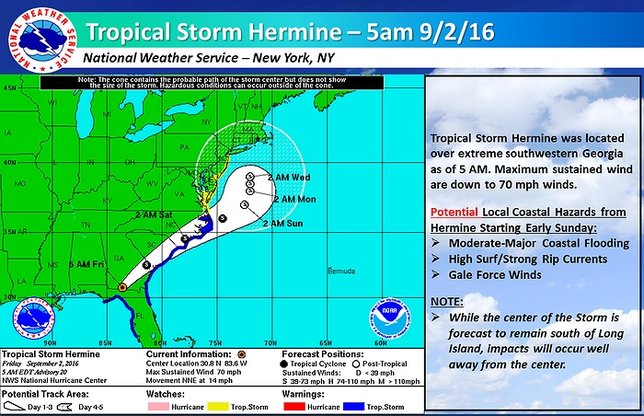
Tropical Storm Hermine downgraded from hurricane strength Friday morning after becoming the first hurricane to make landfall in Florida in 11 years. The storm left a trail of floods and destruction as it knocked out electricity for hundreds of thousands of people on its path to Georgia.
The storm's predicted track has moved slightly westward and its predicted pace northward has slowed as well, making a direct hit on Long Island all the less likely, though still not implausible. As of Friday morning, the NWS National Hurricane Center was predicting Hermine would remain well south of Long Island over the course of Labor Day Weekend; however, while the center of the storm may be out at sea and closer to Delaware on Monday, it could still have an impact on LI well before it would come this far north.
On Friday, the NWS issued a Hazardous Weather Outlook and Tropical Storm Watch for the region, stating that Hermine could affect LI and surrounding areas starting late Saturday and lasting through the holiday weekend into Tuesday.
The most likely hazards for our neck of the woods will be the potential for moderate-to-major coastal flooding, high surf, strong rip currents, and gale force winds. Heavy rain is also a possibility depending on the exact track of the storm, and beach erosion may occur as well.
Although no School Closings or Delays have been announced yet, be sure to check our Long Island School Closures Page for the latest updates on your local district closings.
For the most up to date weather information, head over to the LongIsland.com Weather Center, where you can find the latest weather forecasts, advisories and more.
To get the latest traffic & road conditions before traveling, visit the LongIsland.com Traffic Center, and be sure to check out the live traffic feeds on our Traffic Cam Page.
[Source: NWS]


