

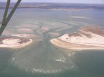
The New Inlet, March 29th
Photo By : SoMAS
Photo By : SoMAS
The New Inlet, March 29th
- Uploaded 12 years ago
- 10702 times
SoMAS regularly takes pictures of *The New Inlet* as part of its monitoring activities. This shot shows just how much the New Inlet has started to shoal up these past several weeks, and how clear and clean the bay water is around it
Add your comment...
 Loading...
-
Nearby NYC
Photos throughout New York City -
The Old Inlet, March 27th
At The Old Inlet, looking north. Shoaling is well underway -
Save The Great South Bay
Dedicated to revitalizing The Great South Bay -
Seals in Carman's River 3-27-13
Due to the nice fresh Ocean water flushing Great South Bay water... -
2014-2015 Long Island Holiday Photos
There is always tons of stuff to do here on Long Island during the...
- Things To Do
- Places To Go
- Events
- Museums
- Vineyards
- Restaurants
- Nightlife
- Beaches
Copyright © 1996-2017 LongIsland.com & Long Island Media, Inc. All rights reserved.